The Republic of Somaliland Oil Exploration Production
Somaliland Block SL10B/13
Company Profile – Genel Energy
◼ Anglo-Turkish E&P company – listed on the London Stock Exchange (LSE)
◼ Operations
◼ Kurdistan Region of Iraq (largest holder of reserves & resources)
◼ Africa
◼ 3 Producing oil fields
◼ Taq Taq (44%) Tawke(25%) and Peshkabir (25%)
◼ Current net production c.36,500 BOPD
◼ Upside from E&A / pre-production assets
◼ Bina Bawiand Miran(100%) oil & gas developments
◼ QaraDaghappraisal (40%)
◼ Sarta(30%) pre-production
◼ 150 MMBOE net 2P Reserves
◼ 5.5 BBOE net reserves and resources
◼ Africa – High-value, Low-cost Exploration
Africa – Organic Value Creation Through Low-cost Exploration Somaliland
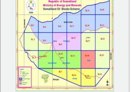
SL10B/13 75% Op
Prospect Inventory Build
Odewayne 50% Op
Seismic processing/interpretation
Somaliland Licence Position
Facts and Figures
Population – c.3.5 million
Geopolitical History
◼ 1888 –British Somaliland (Protectorate)
◼ 1960 –Somali Republic
◼ 1988 –onset of civil war
◼ May 1991 –Somaliland local government declared ‘independence’.
◼ 2019 –28 years of democracy and 5 democratically elected presidents.
Economy
◼ GDP per capita last estimated at US$347 (World Bank) – amongst lowest in the
world.
◼ C.30% of GDP from livestock.
◼ FDI historically low
Why Somaliland?
◼ The Geology –the Yemen Analogue
◼ Prior to the opening of the Gulf of Aden c.20my ago the Somaliland rift basins were
broadly contiguous with the prolific rift basins of Yemen –home to >7BBOE of 2P
reserves.
◼ Specifically Nogal-DabanLate Jurassic rift was contiguous with the Sab’ataynrift.
◼ Potential for Yemeni equivalent BBO+ fairway
◼ Somaliland remains hugely underexplored for non technical reasons –a political
discontinuity……
◼….but deep basins and a working petroleum system are both proven.
◼Vast acreage position (>40,000 sqkm)
◼ First mover advantage –acreage capture already ‘basinal scale’ –play opening
discovery gives potential for repeatability on a very large scale.
Somaliland – Exploration History
◼ Somaliland remains hugely underexplored – a genuine political discontinuity.
◼ 26 wells drilled (including 7 shallow stratigraphic tests and only 7 sited on seismic) over a period of 60 years.
During Under British Protectorate:
Mobil and Amerada explorer Somaliland Oil
During 1960 – 1984:
ONLY Shell and Conoco explorer oil in Somaliland since Somaliland was under occupation militarily and economically by Somalia.
During 1991-2025
Genel enter Somaliland oil exploration
Somaliland Exploration Well Locations
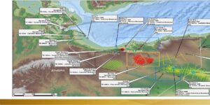
▪ Large gravity low interpreted as a sedimentary basin.
▪ NW fault trends similar to Yemen structural grain.
▪ Intra-basin gravity highs.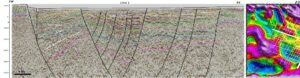
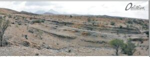
Rift basin architecture
confirmed
▪ Stratigraphic expansion of Upper Jurassic into NW & WNW-trending faults (c.f. Yemen).
▪ Locally >5000m sediments on PSDM data.
▪ Seismically defined “deep basin” >4000 sqkm
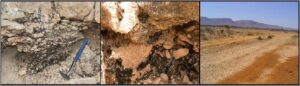
Play Elements – Primary Source Rock Presence
◼ Primary Source Rock – Kimmeridgian Daghani Shale
(equivalent to prolific Madbi shale in Yemen) outcrops
to the North of SL10B/13 at Bihendula.
◼ 350-450 m gross thickness in outcrop (net source rock
c.30%)
◼ 2-8% TOC, up to 16 kgHC/tonne
◼ DagahShabel-1 discovery – mid-30 °API oil to surface
from Upper Jurassic carbonates.
◼ Secondary source Rock – Oxfordian Gahdoleh
formation, black shales, TOC 1-2%.
BLOCK SL10B/13
◼ Seeps identified on Block SL10B/13 and to the north
confirmed by surface passive geochemical sampling and
direct seep sampling.
◼ GCMS analysis of the seeps are consistent with light oil or possibly condensate derived from a clastic source rock.
◼ DagahShabel-1 discovery, seeps in SL10B/13 Kalis-1 and Nogal-1 shows are a strong indicator of an extensive Daghani Fmpetroleum system equivalent to the Madbi Qishn/Amran(!) petroleum system Yemen.
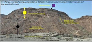
Play Elements –Reservoirs and Seals
Hayira seep was
- Identified in 2013/14 with satellite data
- Sampled with Gore-Sorber modules in 2014
Daghani Fm
- Additional samples collected in 2019 by pit-sampling.
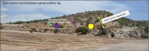
RESERVOIR –multiple targets
◼ Primary QishnClastics
◼ Main producing reservoir in Yemen–Avg. 20% porosity, avg. 1500mD permeability, high NTG, ~100m net thickness.
◼ Outcrops 10 km north of Block SL10B/13.
◼ Seismic evidence for presence on-block.
◼ QishnCarbonates Top-seal
◼ Secondary reservoirs
◼ Jurassic AdrigatSandstone 50-200m thick (GahdolehTop-seal)
◼ Cretaceous Yesommaand GumburoFmSandstones 1500-2000m thick (Intra
formational top-seals proven in NogalBasin wells)
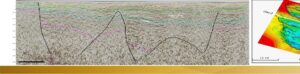
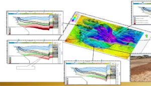
Traps (Prospects & Leads)
◼ Prospects mapped on PSDM seismic data
◼ Inventory of 12 Prospects & Leads defined
◼ Traps are predominantly 3-way dip closures against a
fault (similar to Yemen analogue)
◼ Stacked reservoir targets
◼ YesommaFm
◼ GumburoFm
◼ QishnFm(PRIMARY RESERVOIR)
◼ AdigratFm
◼ Mean closure sizes at Qishn Fm 5 to 33 km2 with large
structural upside
◼ Mean prospective resources range 50-700 MMbbls per
prospect layer (Average Qishn prospect 200 MMbbls)
◼ Stacked reservoirs resource potential gives 200-1500
MMbblsper prospect
Oil Export Feasibility Studies
◼ Third Party study investigating feasibility of exporting
oil from SL10B/13 development
◼ Best export facility likely exists at natural deepwaterPort
at Berbera
◼ Crude export to a refinery in Oman or UAE is favoured
◼ EPS (20,000 bopd) and FFD (50,000 bopd)
development options considered
◼ Oil evacuation by trucking is viable for EPS with volumes
up 20,000 bopd
◼ Oil evacuation by buried pipeline routed west of
mounta