Somaliland land resources
Territorial diagnostic report of the land resources of Somaliland
- Coastal plain and Piedmont:
The most arid landform in Somaliland with uni-modal rain of 100 mm per annum and a temperature of 28-35 ⁰C, the potential evapo-transpiration exceeds the rainfall by thirty times. With mixed quality 18 boreholes were found with 105 m average depth. The soils of the landform (represented by Arenosols and Regosols) are poor in texture, structure and fertility. Due to aridity and the absence of adequate land cover, sheet and gully erosions prevail and the eastern two-third part of this landform undergoes continuous land degradation. 4% of the landcover is woody vegetation scattered between Zeylac and Berbera, and only 0.02% is irrigated agriculture near Berbera. With 95% of either bare land or covered with herbaceous vegetation, the landform is associated with nomadic and transhumance pastoralism.
- Mountain and Highlands:
Comprising Golis Mountains, the landform receives 300 – 600 mm of bi-modal rainfall, with 20 – 24⁰C with the potential evapotranspiration equals the rainfall, the ratio is most balanced in the entire Somaliland. 79 boreholes were found with 111 m average depth, with fair quality along the mountains and saline in the valleys. The major soil class is Leptosols (59%) i.e. predominantly rocky and shallow, followed by Cambisols (22%) which are deeper and loamy. The soils generally lack nitrogen, however well in potassium and micro-nutrients, and the soils in the less sloping lower reaches are adequately developed. 63% and 14% of the landcover comprises of herbaceous vegetation and woody vegetation respectively.. The woody vegetation is concentrated in the Golis Mountains but also in the areas surrounding Borama and Hargeisa. With larger part under nomadic pastoralism, 16% landcover is under transhumance pastoralism with timber collection and charcoal production and 2% (1000 Km2) under irrigated agriculture.
- Plateaus:
With largest area in Somaliland the plateau landform receives 300 – 600 mm of bi-modal rainfall. The temperature ranges between 20 and 24 ⁰C and the ratio between rainfall and potential evapo-transpiration is one to one and a half, giving a manageable climatic situation. 162 boreholes were found with 111 m average depth, with rather saline quality. The soils in general are deep, low in nitrogen and phosphorus, high in potassium and other micro nutrients, thus the soils can be reasonably productive by replenishing the fertility through supplying nitrogen and phosphorus. 81.3% (58459 Km2) area is covered by herbaceous or sparse woody vegetation, 2.6% (1936 Km2) area under rainfed agriculture and 0.2% (174 Km2) under irrigated agriculture. Around 23% area is bare lying in the east of Ceel Afweyn. About 70 million hectares (90%) of plateaus is under nomadic and transhumance pastoralism with timber collection and charcoal production, and 256,000 hectares under agro-pastoralism (3.4%).
- Valley
The landform receives less than 200 mm bi-modal rainfall per annum, with temperature of 28- 32 ⁰C and potential evapotranspiration exceeding the rainfall by seven times. The landform is characterised by high aridity. 48 boreholes were found with 119 m average depth and varying saline quality. The soils of the valleys comprise clayey Calcisols 35%, silty or sandy and saline Solonchak 24%, sandy loam Regosols 20% and stony or rocky Leptosols 19%. These soils are low in nitrogen, adequate in Phosphorous and high to average in potassium. The land-cover in this landform consists of about 57.3 % (16,738 ha) by sparse or herbaceous natural woody vegetation and 16.8% (4925 Km2) by closed to open natural woody vegetation. Less than 0.26% (78 Km2) is irrigated agriculture southeast of Burco. Around 94% (2.8 million ha) is under nomadic and transhumance pastoralism and 0.1% (2165 ha) under agro-pastoralism. This landform is also characterised by timber collection and charcoal production activities.
Challenges and Gaps
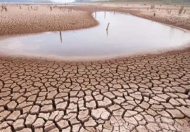
The land resources of Somaliland pose series of challenges and gaps related to biophysical shortcomings, management limitations, and institutional and capacity gaps. The major bio- physical limitations include aridity, ground water insufficiency, climate shocks, poor soils, accelerated erosion, low biomass production and degradation of existing vegetation cover and spreading of invasive species (e.g. Prosopis, Opuntia, Parthenium species, etc.) in productive lands.
Recommendations
The replenishment and sustainable use of the land resources of Somaliland demands the following measures:
Formulation of policy vision and road map for the sustainable governance of the land- resource of Somaliland and capacity enhancement to plan and implement the sustainable land resource management.
Shifting from Business as Usual to Proactive scenarios – challenging the present paradigm, looking at land in totality rather than pieces on the basis of use potential; identifying the interface of one use with the other – looking at land as ecosystem with potential for production of goods and services.
A thorough cost-benefit analysis with focus on the cost and benefits of the business as usual with the more proactive and holistic scenario based on the recommendations listed in this report. The use of modern technologies and input intensive management, the mainstreaming of land resource base small and medium enterprise development, including micro-finance facilitation needs to be examined.
Integrated land-use planning and management to be carried out in an informed, integrated and participatory manner at various levels starting from the smallest unit of land resource i.e. village and subsequently going to the larger unit, ultimately ending at the landform level.
Addressing the issue of aridity by managing land in congruence with the natural capability of the land, thus the potential of plateau and mountain/highlands landforms needs to be optimally used in a cost effective manner. Nevertheless the landform with extreme aridity needs to be managed for other uses such as forestry, through conservation measures. This is essential to check the expanding desertification of these regions, which ultimately spreads to the more promising land resources.
Although the ground water has been mapped in Somaliland, a working level mapping of test pumping is needed. The land use planning process should integrate ground water assessment, including test pumping mapping at micro-level (village/settlement) as well. The recharge requirements should be assessed and measures including water harvesting and
integrated watershed management should be carried out. Awareness and capacity building in the subject of ground water and its replenishment should be tailored and imparted and made part of the land use planning process.
Managing the climate shocks should be done through climate change adaptation measures, its mainstreaming in the government planning process and demonstrations through donors assistance. Climate change shocks preparedness and resilience should be done together with disaster management authority. Awareness and Training packages need to be developed and imparted. Climate smart agriculture and livestock management should be demonstrated with the help of UN agencies and donors.
Limited soil fertility should be managed through a holistic approach including nutrients adding, conservation measures, crop rotation and shifting, encouraging Leguminosae plant species and encouraging cost effective subsidies.
The issue of invasive plant species should be addressed through national level efforts and the formulation of a cohesive national strategy based on awareness, eradication and promoting the use of Prosopis for charcoal production as well as substitute to threatened acacia species.
Addressing the ecosystem fragmentation and degradation through integrated approach including assessing land degradation through LADA / WOCAT methodology and land restoration opportunity identified through use of WOCAT SLM measures. This shall also include creating alternative livelihoods and income generation activities through skills training and development of innovative entrepreneurship arising from the ecosystem goods and services. The charcoal issue should be addressed through enforcement as well as replenishing the deforested areas and providing alternative energy sources and livelihoods options for the local communities. Comprehensive and cohesive grazing land management strategy and its demonstration is also included.
The issues of ecosystem degradation & fragmentation, droughts and floods and desertification should be addressed through mainstreaming of the biodiversity, climate change and combating desertification through the trust funds such as GEF, Adaptation Funds, Green climate fund, Special Climate Change Fund, etc.
Holding of an international conference on the land-resources of Somaliland in general as well as assessing/exploring the indigenous knowledge related to land and its uses and integrating this with the contemporary knowledge of the government and research organizations.
1.2. Introduction to the land resources of Somaliland
Situated in the horn of Africa, Somaliland has a total area 137, 600 Km2 with a coastline of 850 Km along the Gulf of Aden (MONP&D Somaliland, 2015). For the analysis of the associated land resources, we refer to FAO that define Land and Land Resources as a delineable area of the earth’s terrestrial surface, encompassing all attributes of the biosphere immediately above or below this surface, including those of the near-surface climate, the soil and terrain forms, the surface hydrology (including shallow lakes, rivers, marshes and swamps), the near-surface sedimentary layers and associated groundwater and geo- hydrological reserve, the plant and animal populations, the human settlement pattern and physical results of past and present human activity (terracing, water storage or drainage structures, roads, buildings, etc.) (FAO/UNEP, 1997). Under the overall context of this formulation and together with FAO land resource framework, the SWALIM knowledge base of land resource is incremental in nature. While building on the overall FAO knowledge, SWALIM incrementally generated literature related to the Somaliland land resource through field surveys and extensive use of remote sensing and GIS techniques. SWALIM’s review of these land resources in snapshot is as follows:
1.2.1. Climate:
Arid and Semi-Arid Lands (ASALs) make up most of the landmass of Somaliland, and these are characteristically prone to extreme weather conditions including high mean surface temperatures, periods of extended drought, highly erratic rainfall and strong winds (UNDP/ICPAC, 2013).
The main synoptic scale systems affecting rainfall in Somaliland include the Inter-Tropical Convergence Zone (ITCZ), monsoonal winds and ocean currents, jet-streams including the ‘Somali Jetstream’, easterly waves, tropical cyclones, neighbouring Indian Ocean and Red Sea conditions, as well as tele-connections with various regional and global scale climate systems. The large-scale systems include the Quasi- biennial Oscillation (QBO), El-Niño/Southern Oscillation (ENSO), Indian Ocean Dipole (IOD), and intra-seasonal waves (UNDP/NAPA, 2013).
SWALIM has not only accessed and analysed substantial information on the climate but based on potential evapotranspiration (PET) and rainfall variability has developed the length of growth period (LGP) map and legend for the whole of Somalia which can be conveniently delineated for Somaliland. Nevertheless the detail LGP for the Northern AOI is effectively derived. By combining LGP with aggregated soil groups agro-ecological zoning of Somaliland generated with 29 main zones and 3 inter-zonal regions defined by landforms.
1.2.2. Landforms:
The landform of Somaliland was mapped while using integrated landform mapping approach at semi-detailed scale using Remote Sensing and GIS techniques. Methodologically the study on the landform of Somaliland succeeded in achieving a legend system. This system takes into account the integrated use of satellite images, topographic and other thematic maps, DEM and their derived products, and 3D visualization, for identifying and mapping the landforms of Somaliland with the greatest precision. This legend is also suitable for soil mapping and identification of the hazards such as erosion and flooding. A full list of the Landform automatic classification and an explanation of the conceptual background is provided. These efforts led to the formulation of 14 landform types together with its coding, extent and description with a limited reflection on its relation with the productive potential of the land resource associated with the respective landform type.
1.2.3. Soils:
Although the first regional soil reconnaissance survey was conducted in the Juba and Shebelle region by FAO-Lockwood in 1967, the first systematic soil survey of Somaliland was conducted by Sogreah in 1981 (Vargas, R. R., Alim, M. 2007). In the period 1987-88 ISRIC carried out the soil inventory on 1:1 million scale soil map on the basis of information that existed at that time. The map and associated data were digitized by FAO in 1998 in the shape of Land and Water Digital Media Series 2. This map was later simplified by SWALIM for land evaluation and the demarcation of Agro-ecological zones (AEZ). The various soil groups were aggregated in seven classes based on physical limitations to crop production as well as in conformation to the World Reference Base for Soil Resource 2006.
In producing soil data SWALIM used multi-scale and multi-user approach so as to be effectively and readily used by the natural resource managers. Most soils found in the study area (covering parts of Borama, Gebiley, Hargeisa, south of Lughaye) belong to the class with very limited soil development, with 45% of the soils being rocky/stony with limited potential for agriculture. This nature of the soil is mainly due to peculiar geography of the area as arid and hilly terrain on one hand and the less adequate human activities on the other. Soil fertility is low as these are continuously degraded due to agro-pastoral activities with almost no application of fertilizers (Vargas, R. R., Alim, M. 2007).
1.2.4. Land use/land cover:
The landuse and landcover were assessed for Somaliland through sampling techniques with USGS methodology using grid spacing of 500 m and with the help of 15 m resolution ASTER satellite images of 2013. The work was supplemented by very high resolution images and interpreted through NDVI images. Landcover maps were developed for the whole of Somaliland as well as for individual districts. The landuse classes were created using the FAO standardized LCCS v.3 methodology (http://www.glcn.org/ont_2_en.jsp).
In general seven land-cover classes comprising natural woody vegetation (sparse trees & herbaceous canopy together with closed to open canopy) covering 75 % of the area followed by bare area covering 23% of Somaliland. The rain-fed crops cover around 1.71%, whereas irrigated crops cover only 51 ha area giving about 0.01% of Somaliland. These land-cover classes together with the soils, landform and climate determine the nature of the land use.
In the Northern AOI (Somaliland) around 60% area is used purely for grazing including transhumance pastoralism and about 40% for crop production where rain-fed agriculture is practiced in combination with pastoralism and wood collection. Goats and sheep are grazed mainly on sloping areas, whereas cattle and camels are grazed on flatter areas. This land use class is the economic basis of households in the study area. Sedentary pastoralism around homesteads is a common practice. Hay harvesting supports this land use, as harvested hay can be used during the dry season. The Sorghum belt of Somaliland typically represents rain-fed agriculture, where a variety of water harvesting techniques intended at water retention was found. However, these structures are inadequately constructed and in some cases lead to severe gully erosion. Irrigated agriculture is mostly confined to orchards and vegetable crops growing as cash crops. These crops are irrigated through wells, dams and other water bodies, which are generally poorly constructed, leading to water losses and erosion. Uncontrolled grazing together with deforestation for charcoal production has led to degradation of areas under woody vegetation (Oduori, S., Vargas, R., Alim, M. 2007).
Thus, on the face of resource scarcity on one hand and the poor management practices on the other a bleak situation is presented in most of the available literature. Nevertheless, options are available which can help in bringing conducive changes that requires an informed, shared and robust management based on the analysis of reliable and sufficient data.
1.2.5. Land evaluation of Somaliland (Northern Area of Interest)
SWALIM developed Somali Automated Land Evaluation System (SOMALES) by adapting FAO Automated Land Evaluation System (ALES) to the Somali context. SWALIM developed resource based units (RBU) by superimposing the multi-temporal and multi-spatial land resources (soils, land use, land cover and landform) together with agro-climate on a scale of 1:100,000. RBU formed the basic unit of land evaluation. The generic land uses of Somaliland comprise of rainfed agriculture, irrigated agriculture, extensive grazing (pastoralism) and forestry (tree plantation). SOMALES provided four suitability levels: highly suitable, moderately suitable, marginally suitable and not suitable. Thus the evaluation reveals the various levels of suitability for each of the four land uses in every RBU for the Northern AOI. Due to the absence of cost/benefit analysis for various LUTs a comparative analysis couldn’t be developed. Nevertheless, some qualitative assessments with details available in FAO-SWALIM Report No: L -12, 2007.
1.3. Conclusion
Together with FAO land evaluation framework and UN guideline for land policy formulation, SWALIM has developed substantial information in the form of reports and maps that can effectively support the overall bio-physical assessment of the land resources of Somaliland. Nevertheless the following issues were identified:
- The Geographical and Ecological Context (Bio-physical data): as mentioned before substantial data is already available. Nevertheless information on the feasibility of small scale irrigated agriculture needs to be available specifically on the sources and its distribution, its current status and proposed improvement measures with associated investments would be needed. This context also shapes the ecosystems, watershed functions, biodiversity, etc. notwithstanding SWALIM lack of information on this aspect will be compensated through the recently completed NBSAP Somalia in general and Local Biodiversity Strategy and Action Plan of Somaliland in particular.
- The Politico-institutional Context: This refers to statutory control, regulation, legislation, policy, strategy and plans to manage the land. This aspect also includes the issue of capacity and state institutions responsible for political and administrative steering of the land. This will be collected through the semi-structured interviews and focussed group discussion with experts and government officials of Somaliland.
- The Economic Context: this covers the role of land in agriculture and other green sectors economy as well as the role of economy in land resource management. Not substantial analysis is available and data is sketchy. Due to the very important role of land and its very intricate and vulnerable nature the multi-dimensional cost-benefit analysis is as important as the bio-physical analysis while planning for realizing optimum production of the land.
- The Social and Cultural Context: land plays a dominant role in shaping the power structure in agro-pastoral societies. Therefore, the issue of ownership, tenure, marginalisation, gender, conflicts, spirituality, etc. becomes very important. Data about the socio-cultural aspect of land will need to be obtained.
- The Demographic Context: the issue of population increase is affecting land in terms of land fragmentation due to land division and in-cohesive land use change. The issue of urbanization and desertification can also find its root in the demographic context. SWALIM GIS facility may be of help to arrive at the urbanization vis a vis its impact on the land. Along with the land use, the land use change would also need to be assessed.
- Climate and Ground Water of Somaliland
This chapter is intended to cover the climate and water resources as critical input for the productive potential of the land. The climate section of this chapter covers both the precipitation and temperature, whereas the ground water is covered as separate section in this chapter. Both the climate and ground water of Somaliland have been extensively studied by SWALIM. The climate is studied through the establishment of an extensive weather monitoring network that includes both manual and automatic observations stations. A total of 32 weather observation stations are installed at strategic locations throughout Somaliland that include the pre-war stations to facilitate the use of the long series of historical data in weather analysis, for details read Map 1. The information present here highlights key climate factors that relate to land resources development. For a detailed analysis of Somaliland climate, see SWALIM Technical Report W-01.
3.1. Climate of Somaliland
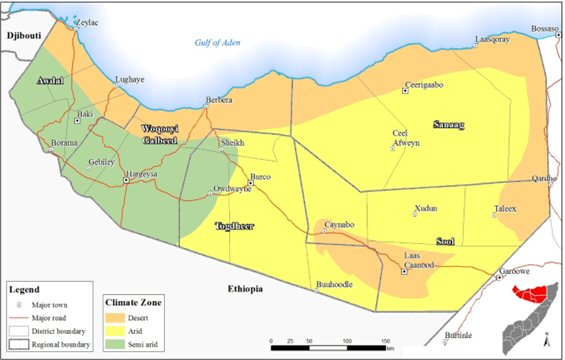
Somaliland has three major climate zones; desert, arid and semi arid. Generally, the climate is a result of the north and south movement of the Inter-Tropical Convergence Zone (ITCZ) that results in a bimodal rainfall pattern with two rain and two dry seasons.
Temperatures are generally high throughout the year, with an annual average maximum temperature of 36 to 38 °C in the coastal areas and becoming slightly lower inland. The highest temperatures are experienced in the months of June through September, becoming cooler in January and February when temperatures decrease substantially to as low as 15 °C. The temperature decrease with altitude is about 6.5°C per 1000m.
Potential Evaporation Transpiration (PET) varies between 1000 to 3000 mm/year with mean annual values for the region being greater than 2000 mm/year. PET exceeds rainfall across the region and is highest in dry seasons with values between 280 mm/month inland and 440 mm/month in the coastal areas. In the driest areas, e.g. Berbera, annual PET values exceed 3000mm/year.
Relative Humidity (RH) is relatively low reaching average values around 40% in the lower parts of Togdheer. Generally, RH is influenced by the permanent strong dry wind from the Arabian Peninsula, in particular the Kharif winds, which contain very low moisture content. RH is however higher in the coast areas where it reaches 70%.
3.1.1. Climatic Zones
Detailed analysis of Somaliland weather data reveals three main climatic zones across the regions. These include; (a) desert zone mainly along the coastal belt, (b) very arid zone in the central and western areas and (c) semi arid zone in the lower parts of Awdal and Waqooyi Galbeed (Figure 1). The three zones are further elaborated below:
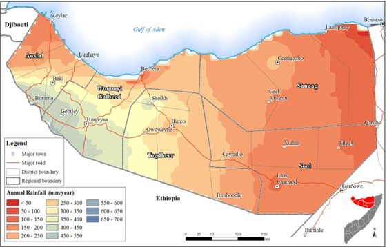
- Desert zone: This zone receives less than 100 mm of annual rainfall and the rain seasons lasts for one month only. The coastal belt of Somaliland and a small portion in southern Sool region falls under this kind of climate. Major towns in this zone include Zeylac, Lughaye, Berbera, Lasqooray and Laas Caanood. Rainfall is unreliable while daily average temperatures are above 300C. The desert zone is unsuitable for cropping and pastoralism is the common land use.
- Arid zone: This zone receives less than 400 mm of annual rainfall and the rain season lasts for a maximum of three months. Rainfall usually comes in heavy showers and a large proportion is lost through runoff. Although cropping is possible, irrigation is absolutely essential for success. High temperatures are experienced throughout the year. This zone covers the central and eastern parts of Somaliland and includes town such as Ceerigabo, Ceel Afweyne, Burco and Xudun.
- Semi-arid zone: This zone receives 400 to 600 mm of annual with the rainfall seasons slightly exceeding three months. Rainfed cropping is possible but irrigation is indispensable for reliable and good crop harvests. Some drought-resistant crops such as sorghum and millet may give reasonable yields without irrigation, but there is still a risk of unreliable rainfall and subsequent crop failure. The zone includes inland areas of Awdal and Waqooyi Galbeed regions in the western parts of Somaliland which plays a major role in production of most important food crops for the whole of Somaliland.
From this analysis, it is evident that Somaliland is predominately dry with 75% of the region being either Desert or Arid. Only a small portion of Somaliland to the South West is semi- arid. Somaliland is therefore prone to harsh weather conditions which present a major land resource development challenge.
3.1.2. Rainfall spatial and temporal distribution
This distribution is computed by interpolating the long term mean annual rainfall observed at the different rainfall monitoring stations. From Figure 2, a modest rainfall situation is evident across Somaliland. The lower parts of Awdal and Waqooyi Galbeed regions receive the best rainfall with values between 500 to 600 mm per year. The Central and Eastern parts of Somaliland including Togdheer, Sool and Sanaag regions come next with rainfall values of 100 to 400 mm per year. The rest of the country, particularly the coastal belt and a small pocket of the area south of Sool region are characterized by very low rainfall with values less than 100 mm per year. This modest rainfall is distributed across two rain seasons that are interspaced by two dry seasons. The temporal distribution of the rainfall in Somaliland, like in any other dry environment, further limits and constrains the productivity of the land.
The four seasons experienced in Somaliland are summarized below:
- Jiilaal – This is a dry season occurring from December to mid March. During this season the region experiences cool and dry air. January and February are actually the coolest months of the year in Somaliland. Relative humidity is relatively high with low wind speeds during this season.
- Gu – This is the long rainy season, lasting from late march to mid June and with relatively wet and hot conditions. During this season, there is plenty of water in most areas and is a breeding period for the livestock. Rainfall increases from west to east of the region with the coastal belt receiving minimal rains.
- Xagaa – This is a dry season occurring from late June to September. Though generally a dry season, there are areas that receive scattered showers including Baki, Borama, part of Oodweyne and Hargeisa. Other parts remain very windy and dry.
- Deyr – This is the short rainy season lasting form October to November. The rainfall received is less than that of the Gu rainy season.
3.1.3. Climate of the main landscapes of Somaliland
For the purpose of assessing land productivity, the climate of four major landscapes of Somaliland is presented in the following section. The climatic characteristics of the four landscapes are presented on Annex 1.
Coastal landscape:
The Coastal Plain and Piedmont is a strip that runs parallel to the Northern boundary of Somaliland. This landscape includes the areas of Berbera, Lughaya and Zeylac. It has an altitude of less than 500 meters above sea level (masl). The area has a desert climate and is extremely hot and dry with total annual rainfall below 100 mm and very high temperatures of between 28 and 35oC on average.
The Potential Evapotranspiration exceeds rainfall by more than 30 times and therefore greatly limiting land productivity except for desert vegetation. Rainfall is extremely low and occurs in trace amounts. This landscape does not provide opportunity for crop production. The climatic water demand s extremely high throughout the year but mostly so between June and September.
The Mountain and Highlight (Moist) landscape is South of the Coastal landscape and to the West. This landscape includes the areas around Borama. It has an altitude of between 1200 and 1900 MASL. The area has a relatively moist climate with moderate temperature (20 – 24 oC) and total annual rainfall of between 500 and 600 mm. This is one of the best production areas of Somaliland.
This landscape has a good rainfall distribution with the two rain seasons almost merging to provide a conducive production condition as compared to the rest of Somaliland. The Potential Evapotranspiration is almost equal to the rainfall and therefore good opportunity for production of crops, pasture and other vegetation. This landscape has the highest opportunity for crop production within Somaliland. The months between April and September provides the best period for crop production.
Rainfall and Evapotranspiration
The Mountain and High (Arid) landscape is South of the Coastal landscape and to the East. This landscape includes the areas around Sheikh and Ceerigaabo. It has an altitude of between 1200 and 1900 MASL. This landscape is similar to the moist Mountain and Highland landscape presented in Fig. 3 above but has a drier climate although the average temperature remains between 20 – 24 ⁰C.
The landscape has two rain seasons with total annual rainfall of between 300 and 500 mm but the Potential Evapotranspiration is almost three times the rainfall and therefore limited potential for crop production. The moderate rainfall however provides good opportunity for production of pasture and other vegetation. The months between May and October experience very high climate water demand and therefore more limited growing condition.
Plateau (Semi-Arid) landscape
The Plateau (Semi-arid) landscape is south of the Mountain and Highland (Moist) landscape and to the West by Valley landform. This landscape includes the areas around Wajaale, Gebiley and Hargeisa. It has an altitude of between 1200 and 1500 MASL. This landscape is similar to the Semi Arid Mountain and Highland landscape presented in Fig. 4 above but has a slightly drier climate although the average temperature remains between 20 – 24 ⁰C. The landscape has a total annual rainfall of between 500 and 600 mm which is distributed across two rain seasons which almost join together to provide a conducive crop and vegetation growing condition. The landscape Potential Evapotranspiration is one and half times the rainfall and therefore good potential for crop and vegetation growth. The landscape comes second to the Semi Arid Mountain landscape in terms of the land production potential.
Plateau (Arid) landscape
The climatic characteristics of the Plateau (Arid) landscape are presented in Figure 6 below. The Plateau (Arid) landscape is in the South of Somaliland and includes the areas around Burco, Oodweyne, Caynabo, Ceel-Afweyn, Dhahar and Badhan. It has an altitude of between 500 and 1200 MASL. This landscape is similar to the moist Plateau landscape presented in Figure 5 above but has a drier climate. The average temperature is around 27 ⁰C.
The landscape has a total annual rainfall of between only 200 and 300 mm which is distributed across two rain seasons. The landscape Potential Evapotranspiration is more than six times the rainfall and therefore very limited potential for crop and vegetation growth. The months between June and September experience very high climatic water demand. The potential for crop and vegetables can be substantially improved with small scale irrigation.
Valley landscape
The Valley landscape includes the areas around Laascaanood, Taleex and Xudun. It has an altitude of between 500 and 1000 MASL. This landscape has both Arid and Desert climate with average mean temperature of between 28 and 32 ⁰C. The landscape receives less than 200 mm of annual rainfall which is spread across two rain seasons with a very distinct dry season between the two seasons. The landscape Potential Evapotranspiration is more than seven times the rainfall and therefore very limited potential for crop and vegetation growth within this landscape.
3.2. Groundwater Resources of Somaliland
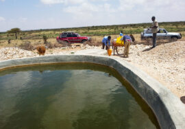
Groundwater is the primary source of water supply in Somaliland, mainly from boreholes, springs and dug wells. Surface water resources in the region are limited to seasonal rivers (togga) and small water catchments which hold water only during rainy season. Potential groundwater aquifers occur extensively throughout Somaliland with varying characteristics regarding depths, yields and quality aspects. Recharge to the aquifers is limited by limited rainfall, high evaporation and short runoff events. A study by SWALIM (Hydrogeological Assessment of Somaliland and Puntland, 2012) classified areas with groundwater potential in Somaliland into two categories, considering the water quality and aquifer depth:
- Areas of shallow to moderate deep well and fair to good water quality located along the coastal belt, along streams in the mountainous areas and sloping escarpment of Somaliland.
- Areas of very deep wells with poor quality water along the plateaus and valleys in Togdheer and Sool regions.
Within the dry river beds there are often shallow perched aquifers of 2 – 20m depth found in the alluvial sediments and within the flood plains.
The depth of boreholes in Somaliland varies from less than 30m up to almost 400m, with yield from as low as 0.5l/s to over 17l/s. Very deep low yielding aquifers compounded by high salinity are the major challenges facing development of groundwater resources in Somaliland. Map 1 shows the spatial distribution and variation of borehole depths across the four major landforms in Somaliland.
Somaliland has a vast area of land under plateau. Accordingly, there are many boreholes established along the plateaus, with varying depths. According to the water sources database in SWALIM, the borehole depths along the plateau range from 37 – 370m. Majority of these boreholes are very deep, 61% over 150m deep. Only 14% of the 164 boreholes are less than 100m deep (Table 1). The water quality of majority of boreholes drilled in the plateau is poor, mainly due to elevated levels of salinity.
In the mountains and highlands areas of Somaliland boreholes are generally shallow compared to other landforms. There are 41 boreholes (52%) with depths less than 100m, and only 17% are more than 150m deep. Along the valleys 42% of boreholes are within 100m depth; 33% are between 100 – 149m deep while 26% are deeper than 150m. Water quality along the mountains is generally fair but gets poor in the valleys, again due to high salinity levels.
The area classified under coastal plain in Somaliland is small compared to the other three classes. Only 18 boreholes fall under this landform, out of which 8 (44%) are shallow with depths less than 100m, and 17% deeper than 150m. Water coming out of the boreholes established along the coastal plain is of mixed quality.
High salt concentrations in the groundwater of many wells across the different landforms in Somaliland render them marginally suitable or unsuitable for humans and/or livestock. The groundwater quality is related to the chemical composition of geological formations through which the water has passed, as well as to the balance between recharge and discharge. Concentrations of chemical components vary widely depending on the location and type of water source. In general, very few groundwater sources in Somaliland conform to international standards as the salt content commonly exceeds 1 g/l, which under normal circumstances is the upper limit for human consumption. However, acceptance of water with relatively high ion concentrations is a necessity, as there is usually no alternative (Milanovic, 2012). Shallow aquifers contain less salt content, but are often bacteriologically contaminated.
3.3. Run-off and Surface Water Resources of Somaliland
The ground water at the moment is the only major water resource for irrigation in Somaliland, which by no mean is sufficient, and with increasing climatic shocks this is further endangered. On the other hand it is quite common that Somaliland receives huge volumes of runoff within a very short period of time as a result of torrential rains. The generated run-off triggers massive erosion and also floods. In this situation the Somaliland authorities have contemplated to come up with ways of not only containing the run-off but to harvest this water for replenishing ground water resources as well as irrigation. The major challenge in this case is to quantify the generated runoff from various catchments, as this requires a systematic monitoring network for a longer period of time. SWALIM conducted a study in collaboration with Somaliland Ministry of Agriculture and Water Resources at Tog Waheen Basin to develop a methodology for estimating generated surface runoff. The study however could not provide sufficient information that can guide systematic water harvesting at the catchment level. The study concluded that much more data on rainfall and river flow need to be collected for sound analysis of the rainfall – runoff relationship in the basin, and development of methodology for estimation of surface runoff for a period of 10 – 15 years before analysis is done. The long term data collection ensures that rain and river flow data for almost all possible scenarios in terms of magnitude and intensity are captured making the results obtained a good representative of the basin under investigation.
- Landforms and Soils of Somaliland
5.1. Landforms
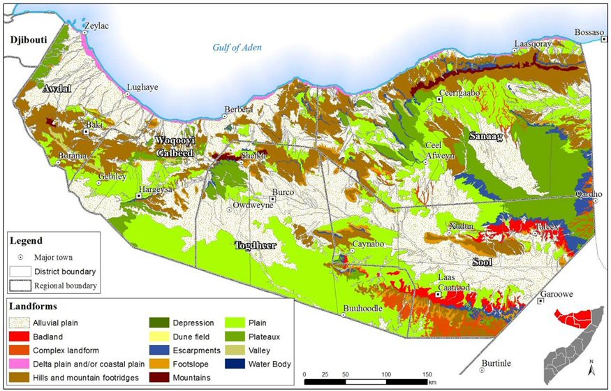
The physical terrain, that substantially influences the productive potential of land, is explained in terms of hierarchical order of landscape, relief and landform. SWALIM has adopted landform to analyse the morphology of physical terrain mainly through two sources; a. Landform of selected study area (Northern Area of Interest) in Somaliland (FAO SWALIM Project Report L-02, 2007) and b. the Landform map of Somaliland. The report is produced while using integrated landform mapping approach at semi-detailed scale using Remote Sensing and GIS techniques. The different terrain classes are distinguished on the basis of topography, slope angles, size & shape, drainage pattern & density, surface geological conditions and colour, tone, pattern and texture. Various types of landscapes, reliefs and landforms were explained, coded and subsequently recorded in the survey process.
A legend system for the landforms of Somaliland is developed through the integrated use of satellite images, topographic and other thematic maps, DEM and their derived products, and 3D visualization. Beside precise, this legend is also suitable for soil mapping and identification of the hazards such as erosion and flooding. To prevent erroneous entering of codes of landscape/relief/lithology/landform and increases reliability and quality of entered data, a GIS based system using ESRI and ArcGIS was developed and used. A full list of the Landforms together with their explanation and conceptual background is provided. These efforts led to the formulation of 14 landform types together with its coding, extent and description with a limited reflection on its relation with the productive potential of the land resource associated with the respective landform type.
Lithologicaly, Somaliland is characterised by the presence of igneous, sedimentary and metamorphic rocks. Morphologically Somaliland is characterised predominantly by a flat coastal plain in the north, that joins extended alluvial plain and culminates into steeper mountains. The hills and mountains occupy most of the central and north-eastern Somaliland. These mountains run SW-NE alignment. South of the mountains and hills is the plateau and extended plain, however with spread over escarpments and bad-land in the southeast.
According to the slope pattern the morphology can be grouped in four sectors: a. coastal sector with modest slope towards the south; b. mountain-hill sector with slope frequently higher than 50% and occupy a considerable (over 6%) area of Somaliland; c. an expanded alluvial plain runs north-west to central-east with low slope (below 16%), occupying an area around 26%; d. the plain forms the central eastern part, however predominantly forms the southern part and covers around 50% of Somaliland, this is almost flat with slope seldom above 4%.
The constraints and potential of these landforms greatly varies as well as their potential in relation to soil formation, moisture retention and response to biological, climatic, demographic, etc. pressures. Certainly the use options and management requirements greatly varies with the varying landscape. This needs a detailed description; however this shall be catered for in this overall territorial diagnostic report.
Based on the similarity and the dominance, various landforms are merged together into four landforms as follows:
These landforms are used in the analysis of all the land resources and the overall conclusion and recommendations of this report are devised, while taking these four landforms as the distinctive yardsticks for the land resources of Somaliland. The following map provides the delineation of these four classes of the landforms.
The first study on Soils of Somaliland was conducted by North-West Region Agriculture Development Project in 1983. This survey covered an area of 33500 Km2 at a scale of 1:500,000, and established that the parent material of the soil belongs to metamorphic, Jurassic, cretaceous, volcanic, alluvial and calcareous formations. Based on these origins, together with type of deposit and degree of weathering the soils were classified into four orders (Aridisols, Entisols, Mollisols and Vertisols), rock-land form. In the period 1987-88 ISRIC carried out the soil inventory on 1:1 million scale soil map on the basis of information that existed at that time. The map and associated data were digitized by FAO in 1998 under the Land and Water Digital Media Series 2. This map was later simplified by SWALIM for land evaluation and the demarcation of Agro-ecological zones (AEZ). The various soil groups are aggregated in seven classes based on physical limitations to crop production as well as in conformation to the World Reference Base for Soil Resource 2006. Most of Somaliland is characterized by an association of shallow and/or stony soils and somewhat deeper calcareous soils. A small area with deep, clayey soils is found south of Gebiley in south-western Somaliland.
Because of the peculiar geography of the area and prevailing aridity most of the soils of Somaliland are less developed with 45% soils were found to be rocky/stony with limited potential for agriculture. Soil fertility in general is low due to continuous depletion and almost no application of fertilizers.
5.2.1. Occurrence and location of the soils of Somaliland:
As described in the methodology section of this report the soils of Somaliland were assessed and mapped resulting in nine soil classes: Vertisols, Calcisols, Fluvisols, Regosols, Cambisols, Arenosols, Gypsisols, Leptosols and Solonchak.
Five classes of soil namely Leptosols, Calcisols, Cambisols, Solonchak and Regosols dominantly prevail in Somaliland. The other four classes (Gypsisols, Arenosols, Fluvisols and Vertisols) also occupy considerable extent of area; the distribution of these soils is shown in the following map:
5.2.2. The productive potential of the soils
The parameters that determine the productive potential of soil are mainly texture, structure, pH value, Electric Conductivity. The texture is the proportion of sand, clay and silt in the soils and this determines the moisture holding capacity of the soil. The fertility is referred mainly to nitrogen, phosphorus and potassium, as in Somaliland the micro-nutrients is not a big issue, even potassium value is appropriately found in most of the lands otherwise fit for agriculture. Given the vast array of the soil structure in Somaliland, generic description is made. Due to the higher pH value, the soils are predominantly alkaline and don’t have the issue of micro-nutrients as well as potassium deficiency. The Electric Conductivity (EC), that determines the salinity of the soil, however doesn’t pose a major challenge in Somaliland as the EC value is within the desirable limits and the salinity is not a major issue. Table 2 briefly explains the soil physical and chemical properties as follows:
5.2.3. Description of soil classes
Based on the chemical and physical analysis of the soils classes, the soils of Somaliland are described as follows:
Leptosols: This is the dominant class of the soils of Somaliland covering around 29% of area (49014 Km2) and are commonly found on the mountains (Golis and Karkaar) and also in the plateaus and dissected plateaus. From the surface to the depth, these soils are made up of stony and rocky formations without soil development. These soils are very shallow over continuous rocks; on the other hand these are also extremely gravelly or stony. These characteristics make these soils of limited suitability for agriculture.
Landuse significance: This soil type has limited potential for any specific intensive use such as agriculture or agroforestry. Nevertheless the soil type has some potential for wet season grazing and as forest land. The vegetation cover consists of general open shrubs, open trees with shrubs and open herbaceous with shrubs. Due to Excessive internal drainage and shallowness that can cause drought, the soils mainly need conservation and therefore natural vegetation cover should be maintained.
Calcisols covers around 22% of area (37011 km2) and commonly occurs in the dissected plateaus and some piedmonts. They are developed in calcareous parent material. The lower parts of the landscape is mostly alluvial and colluvial consisting of base-rich weathered deposits consisting mainly of highly calcareous sands and gravel of colluvial and alluvial soil deposits. The majority of the Calcisols have a clayey texture which slightly changes with soil depth. These soils are strongly calcareous, moderately to strongly alkaline, not saline, have adequate to high cation exchangeable capacity, high to adequately or rarely excessive content of phosphorus and deficient in organic matter and total nitrogen.
Landuse significance: Although low in surface organic matter, have good amount of soil nutrients and also good in water holding capacity. Most of these soils are under shrubs, grasses, herbs and sparse trees and used as grazing lands. These soils are good for rainfed agriculture with sorghum and maize where farming is not hindered by surface stoniness, shallow petro-calcic horizon or aridity.
Cambisols cover around 15% of area (26120 Km2) of Somaliland and occur from flat to gently sloping surfaces of alluvial deposits. The soil texture is within the loamy classes. These soils are moderately alkaline in soil reaction, non saline to moderately saline, high to moderate cation exchangeable capacity and high base saturation and strongly calcareous. They are deficient in nutrients, specially nitrogen and phosphorus.
Landuse significance: These soils are medium to deficient in fertility especially nitrogen and phosphorus with high degree of erosion in mountain areas, these soils are commonly used for grazing and wood harvesting. In the presence of water sources small irrigated fields of fruit trees and herbaceous crops (pulses and vegetables) are practiced. The soils require soil and water conservation measures to be in place.
Solonchaks found in 13% of Somaliland (22285 Km2) are soils with high concentration of soluble salts at certain times of the year. They are located in playas (a desert basin with no outlet which periodically fills with water to form a temporary lake).
Landuse significance: These soils support mostly scattered vegetation (halophytic plants), allowing very marginal levels of grazing activity. Soil and water conservation activities are required, along with controlled grazing and avoiding clearing the land for agriculture.
Regosols occurs in around 12% of Somaliland (20248 Km2) and comprise all the soils that cannot be referred to any other reference soil group. These soils occur in the arid and semiarid environments in variable relief types in the landscape. These soils are shallow and have a uniform sandy loam texture, strongly to moderately alkaline reaction, are not saline, have high cation exchange capacity, high base saturation, are strongly calcareous and deficient in phosphorous and nitrogen.
Landuse significance: Poor in fertility, these are delicate soils with low moisture holding capacity and susceptible to severe erosion that make these soils of minimal significance for agriculture. These soils are used extensively for communal grazing and wood collection.
Gypsisols occupies around 5% of the area of Somaliland (8,494 Km2) Gypsisols are developed in mostly unconsolidated alluvial, colluvial and aeolian deposits of base rich material. In Somaliland, Gypsisols are found in Gebi/Dharoor Valley south the Golis mountain and east of Badhan town. These soils are formed in an arid zone, where Evapotranspiration exceeds the rainfall and the soils have secondary accumulation of gypsum forms on gypsiferous parent material. The soil texture has high silt content which result in surface crusting that dramatically reduces the infiltration rate and consequently have low water holding–capacity. Also the surface has stoniness and uneven subsidence of the land surface and widened cracks and holes due to dissolution of gypsum in percolating water into the sub-surface, the components of calcium sulphate enter solution in the parent material and are transported upward in solution.
Landuse significance: These soils have low availability of major plant nutrients such as nitrogen, phosphorous, potassium and magnesium. The natural vegetation is sparse and dominated by ephemeral grass and/or trees and xerophytic shrubs. In Somaliland these soils are used only for extensive grazing.
Arenosols occurs in 4% of Somaliland (6914 Km2) are soils in the coastal plains that consist of deposits with finer material of loamy sand texture of recent alluvial deposits. These are highly permeable and have low water storage capacity. They are strongly alkaline in reaction and are not saline. These soils are deficient in soil nutrients, particularly organic matter, nitrogen and phosphorus.
Land use significance: The vegetation cover on these soils varies from bare soil with scattered vegetation (open herbaceous and closed strips of Prosopis species along the streams). The soils are not favouring cultivation of crops and transhumance grazing and sedentary pastoralism prevails where most common grazing animals are goats and camels.
Fluvisols occurs in 0.3% of Somaliland (526 Km2) and are young soils developed on parent material of recent alluvial plains, river fans and tidal marshes which are periodically flooded by seasonal rivers within Golis and Karkaar Mountains or Al Mountains, highlands and dissected plateaus. Topography is flat to gently undulating surface.
The major physical and chemical factors limiting crop production usually relate to soil texture, alkalinity, and high levels of salinity. The majorities of these soils have good water drainage and water holding capacities, and are periodically flooded. The soil texture is sandy loam. The pH ranges from moderately alkaline to strongly alkaline, varying with depth or spatially. All Fluvisols are deficient in organic matter and nitrogen and phosphorus is low.
Landuse significance: with the application of fertilizers, the soils are usually suitable for all uses. These soils are commonly used for irrigated crops or grazing and woodcutting for fuel wood in the absence of irrigation.
Vertisols occurring in 0.1% of Somaliland (189 Km2) are churning, deep heavy clay soils with high proportion of alternately swelling and shrinking clays during wet and dry seasons respectively. In these soils, clay content increases with depth. In dry season the soils develop grumic and granular structure in the upper horizon, deep vertical cracks. In the subsoil there are prismatic, angular and sub-angular structures. The Vertisols have relatively high water storage due to the high clay content. The stored water is very important for the survival of crops and plants during the cropping season.
The chemical factors limiting crop production are usually related to the increase of soluble salts in the soil, these soils are moderately alkaline in reaction and moderately base saturated. Salinity is uniformly low throughout the soil profile. The levels of exchangeable sodium are generally very low. The organic matter and total nitrogen in the topsoil are lower than deficient. Therefore nitrogen fertilizer or manure will be necessary to maintain or increase crop yields under present farming systems. Phosphorus content is often low, so application of phosphorus fertilizer is required and is likely to improve crop production in intensive cultivation systems.
Landuse significance: These are considered productive soils where most agricultural land of Somaliland is found. Good results require water harvesting and soil conservation that increases moisture retention in the sloping areas, therefore good potential production exists under specific soil management practices. Small scale agriculture with sorghum, maize, millet, cowpeas and oat is practiced after rainy season. The area is also used for extensive grazing and wood collection.
5.2.4. Soils by Land forms of Somaliland
As part of the generic plan for developing this report, the soils are further elaborated with respect to four landforms as follows:
- Soils of the coastal plain
- Soil of the mountains and highlands
- Soils of plateaus
- Soils of valleys
Soils of the coastal plain
The landform of the coastal plain stretching from the border of Puntland in the east to the border of Djibouti in the west presents six soil types elaborated as follows:
The soils of the coastal plain are predominantly Arenosols (49%), followed by Regosols (24%) and Leptosols (12%). All these major soils of the coastal belt are not promising for agriculture or other intensive uses due to their chemical and physical properties. The aridity together with the parent material makes these soils deficient in soil nutrients, particularly organic matter, nitrogen and phosphorus. The solonchak (8%) are saline in nature with herbaceous vegetation and are not fit for intensive use. The only promising soils are Fluvisols (2%) and Cambisols (5%) where agriculture can be practiced if other inputs are available. These soils, that make a total of 103,271 hectares in the coastal belt, need water and soil conservation to enable them to be used for extensive grazing and forestry.
Soils of the mountains and highlands
The landform has eight soil types dominated by Leptosols and Cambisols. 58.9% of the landform is under Leptosols soils, which are very shallow soils, highly stony and poor in fertility. These characteristics make these soils of limited suitability for agriculture. The vegetation cover is also variable, consisting of general open shrubs and trees with shrubs and general open herbaceous with shrubs. The soils are not suitable for any specific intensive use and demands soil and water conservation before applying alternative management regimes. 6.7% of the landform is under Regosols soils with fragile land surface, low moisture holding capacity and poor fertility. The soils have minimal agriculture significance. They are used as extensive communal grazing lands and for wood collection and demands adequate water and soil conservation measures to ensure sustainable land management.
22% of the landform comprises Cambisols soils that occur in slopes, denudation surfaces and some alluvial plains. These soils, with medium fertility and loamy textures, offer favourable conditions for grazing and wood harvesting, and also for small scale irrigated agriculture for fruit trees and herbaceous crops (pulses and vegetables). They occurs on severe eroding lands in the mountain areas thus needs to be very carefully handled, with conservation practices and controlled utilization of forest products. 6% of the landform comprise of Calcisols which are well drained with good water holding capacity and reasonable amount of soil nutrients. Most of these soils are under shrubs, grasses, herbs and sparse trees and used as grazing lands. The Soils are good for agriculture use due to their physical properties. These soils are also used for rain-fed agriculture with sorghum and maize where farming is not hindered by surface stoniness or a shallow petro-calcic horizon or aridity.
Soils of the Plateaus
31.5% of landform contains Calcisols which are well drained with good water holding capacity. Due to insufficient rainfall or moist conditions the soils support small scale irrigated agriculture only. These soils are mainly used for grazing and wood harvesting.
18% of the landform comprises Cambisols which have medium fertility and loamy textures. These soils provide reasonable conditions for grazing and wood harvesting, and also for irrigated agriculture for fruit trees and other crops. They occur on severely eroded lands in the plateau areas thus needs to be very carefully handled, with conservation practices and controlled utilization of forest products.
A very small portion (0.3%) of the Plateaus is under Vertisols, deep soils which are good in water holding capacity and are located on flat or gentle slopes.
Beside the above three soil types, others comprise Solonchak, Regosols, Gypsisols and Leptosols which do not offer opportunity for intensive use including agriculture.
Soils of the Valleys
Almost 35% of landform contains Calcisols which are well drained soils with good water holding capacity. Due to insufficient rainfall and moist conditions these soils can support small scale irrigated agriculture only. These soils are mainly used for grazing and wood harvesting.
All the other soil types, beside the above, don’t offer favourable conditions for intensive use including agriculture.
5.2.5 Soils of Burco and Owdweyne
In August 2015, SWALIM carried out soil survey in selected agricultural areas in Oodweyne and Burco districts to provide updated information on the productive potential of soil for the most common soils to local farmers and stakeholders. Accessible sites were selected and stratified random sampling was done from the preliminary land cover map. A total of 79 soil samples were collected in the field. The soil sampling was done in the four major soil classes namely Calcisols, Leptosols, Regosols and Solonchaks of the two districts. This resulted in sampling of more than 18 samples per soil class. Cambisols was left out as this covers a small portion (1 %). The location of sampling together with the soil class and its extent is depicted in map 11.
The chemical properties such as soil pH, macronutrients (total nitrogen, total organic carbon, phosphorus, potassium and magnesium), micronutrients (manganese, copper, iron, zinc and sodium), and Electrical Conductivity (EC) was carried out in laboratory and the summary of the result for the chemical analysis of the four classes is summarized in the following table.
The result shows that the soils in general have moderately alkaline pH, and low in nitrogen, phosphorus and organic matter. The calcium and magnesium content in these soils varies from medium to high. The micronutrients are all normal. The soil electrical conductivity of all the soil types is low meaning that there is no problem of soil salinity in the study area. The moderately high pH values reduce the availability of phosphorus due to its precipitation in the soil solution as phosphate salts. Soil micro nutrients including iron, zinc, copper, and manganese are available to plants as shown by the above results. Fertilizers can be added to soil to increase concentrations of plant nutrients.
Recommendations for major crops of the two districts:
Soil fertility refers to, among other properties, the presence of rich nutrients necessary for basic plant nutrition, including nitrogen, phosphorus and potassium (primary nutrients) and a tolerable soil pH (range 6.0 to 6.8) for most plants and large amounts of top soil. The soils of Burco and Owdweyne are less fertile, therefore for the major crops of the area following inputs are recommended:
Sorghum:
At land preparation apply 5 tons/acre of well decomposed manure or compost. At planting time apply 25 kg/acre of urea. Three weeks after sowing top dress with 50 kg/acre of urea.
Cowpea:
At land preparation apply 5 tons/acre of well decomposed manure or compost and 25 kg/acre of urea. Mix well with the soil.
Pawpaw:
At transplanting apply 20 kg of well decomposed manure or compost and 50 gm of urea mixed with top soil per planting hole. 2-3 months after transplanting apply 25 gm/plant of urea and thereafter apply 50 gm/plant/year of urea 1-2 weeks after the onset of the rains. To determine the right amount of fertilizers, the soil should be tested annually.
5.2.6. Current use and recommendation for adequate management
In general the nine classes of the soils of Somaliland can be categorised into two groups: a. Fluvisols, Calcisols, Cambisols and Vertisols; these soils offer opportunities for intensive use including agriculture and b. Solonchaks, Arenosols, Leptosols, Gypsisols and Regosols are soils with low water holding capacity and poor fertility which do not offer opportunity to be managed for any intensive use.
The following table outlines the soil context of Somaliland including its physical and chemical properties, limitations, location of occurrence, existing management and recommendations for appropriate use.
- Land cover and land use
- Land cover of Somaliland
Various methodologies are used for assessing the land cover of Somaliland, nonetheless keeping in view the scope of this report, mapping done by SWALIM on the dot grid basis is adopted. The entire area of Somaliland has been consistently mapped with a standardized description of the classes present in the legend (LCCS3) and the agricultural areas are precisely estimated. The mapping can also be used as baseline for further studies for assessing ecosystems of Somaliland or for a change assessment. Although the seven land cover classes in the legend are not enough to describe the land cover features in detail, the land-cover assessed through this approach is suitable for estimating intensive uses such as agriculture. Scattered/small sized classes are not consistently detected. Notwithstanding, with the assessment of agriculture as well as the landcover under other extensive uses, this limitation insignificantly hinders efforts at prospective systematic landuse.
The soils, climate and landform of Somaliland have shaped a variety of land cover that is categorized into seven land-cover classes. These classes comprise natural woody vegetation (sparse trees & herbaceous canopy together with closed to open canopy) covering 73.72% of the area followed by bare area covering 24.44% of Somaliland. The rain-fed crops cover around 1.34%, whereas irrigated crops covers only 0.37% (620 Km2) of Somaliland. These land-cover classes together with the soils, landform and climate determine the nature of the land use. The seven classes of the land cover are detailed in the following figure 10.
The landscape with natural or semi-natural vegetation having 15 to 100% density of shrubs and/or trees are classified as natural woody vegetation closed to open covers. The area with woody vegetation having density of 3 to 15%, or 3 to 80% of density with herbaceous (non- woody) vegetation are classed as natural woody vegetation sparse or herbaceous. This class has the highest (57.27%) area coverage in Somaliland, followed by bare areas (24.44%) and then natural woody vegetation closed to open (16.45%). Less than 2% area is under agriculture, both irrigated and rain-fed. Map 5 shows the overall landcover of Somaliland.
6.1.1 Landcover of the coastal plain and piedmont:
Characterised by the very high aridity and poor formation of soils, this landform is predominant (71.4%) covered by natural wood vegetation sparse to herbaceous comprise of scanty trees and grass lands with varying density. 4.2% of area is covered with wood vegetation closed to open found mainly in the area between Berbera and Lughaye. Bare areas cover 23% of Somaliland and lies mainly east of Berbera and along the border of Puntland in most of the Sanaag and the northeast of Sool regions. These areas are mostly bare with natural vegetation of less than 3% density. 2.9 Km2 (0.02%) area is under irrigated agriculture in the south of Berbera, whereas 11.2 Km2 (0.08%) area comprise of water bodies situated in the east of Lughaye. The landcover of this zone is stunted and due to the progressive land degradation in the form of water and wind erosion, the cover is threatened; replenishment will be a huge challenge due to the aridity and erosion. Thus conservation soil and land cover conservation is of immense importance in this landform.
6.1.2. Landcover of the mountains and highlands:
Although considerable area (62.82%) is occupied by natural woody vegetation sparse or herbaceous, followed by bare areas (21.55%), the landform has the highest area under irrigated agriculture (0.54% and 283 Km2). These fields are located south of Sheikh, and scattered around Hargeisa, Gebiley and Borama. The rainfed agriculture (0.9% with 471 Km2) is scattered around Hargeisa and east of Borama. The natural woody vegetation closed to open category covers 14% of the landform with relatively dense patches in the Golis, North of Ceerigaabo and around Sheikh. Woody vegetation with varying density is also found around Gebiley and Borama.
6.1.3. Landcover of plateaus
The plateau landform covers the largest (around 44%) part of Somaliland, the landform harbours the largest (around 3000 km2 and 3 %) area under rainfed agriculture in Somaliland. Rainfed agriculture is cluttered south of Gebiley and west of Hargeisa. The two landcover classes of natural woody vegetation (closed to open and sparse to herbaceous) cover 74% of the land area of this landform. This vegetation occurs mostly in the south along the Ethiopian border as well as south of Ceerigaabo. Thus in terms of the extent this overall landcover is very important. A considerable part (23%) of the plateau is bare area, situated mostly in Sanaag and northern Sool.
6.1.4. Landcover of valleys
Together with bare area, the woody vegetation covers almost the entire (99.64%) valley landform of Somaliland. Although considerable area (74.22%) is occupied by natural woody vegetation sparse or herbaceous, followed by bare areas (25.48%), the landform has the least area under rainfed agriculture, but has 74.8 Km2 (0.26%) area under irrigated agriculture near Ceerigaabo and southeast of Burco. The natural woody vegetation closed to open occupies area south of Golis mountains and some area under Laas Caanood and Caynabo.
6.2. Land uses of Somaliland
SWALIM has categorized the landuse of Somaliland in nine classes. Nomadic pastoralism is the most extensive landuse with 11.5 million hectares covering 67.7% of the total area of Somaliland. This is followed by Transhumance Pastoralism with 3.79 million ha covering 22.23% of Somaliland. Bare area comprises 3.87%, whereas transhumance pastoralism with charcoal production and timber collection together forms 4% of the landuse in Somaliland. Built up area, river bank and water bodies are, though very small land-uses, however quite important in terms of influencing the management of the land resources of Somaliland. The following table provides an overall picture of the landuse of Somaliland:
6.2.1. Land use in the Coastal plains of Somaliland
The coastal belt is dominantly under Nomadic Pastoralism (46.5%) and the Transhumance Pastoralism also forms considerable (34.96%) land use, followed by bare area (18.41%) with no economically significant land use.
6.2.2. Land use in the Mountains and highlands of Somaliland
The Nomadic Pastoralism is the dominant landuse with 74% area of this landform together with other land-uses occupying the remaining area of Somaliland. Agro-pastoralism and Transhumance Pastoralism land-uses have a substantial area, This provides an opportunity for improved management, nonetheless with challenges of conserving the potential through integrated and cost effective landuse management regimes.
6.2.3. Land use in the Plateaus of Somaliland
Both from the extent of the land and the land use, this land form is of immense importance with substantial development potential on one hand and posing the challenges emanating from over-use and degradation of the land resources on the other. This zone has the highest area under Agro-pastoralism standing at 3.42% (255,605 hectares). Beside Nomadic Pastoralism, the transhumance pastoralism with charcoal collection is also a significant land-use. Agro- pastoralism together with Transhumance Pastoralism provides opportunity for socio- economic uplift but has multiple challenges including appropriate landuse planning and soil and water conservation as well.
6.2.4. Land use in the Valleys of Somaliland
This landform is mainly under Nomadic Pastoralism landuse, followed by transhumance pastoralism and some timber and charcoals production. The landuse poses conservation related challenges. Agro-pastoralism is limited to the valleys south of Golis Mountains.
- Production systems, livelihoods, Socio-economic and institutional factors
Somaliland is situated in the Horn of Africa. It borders the Red sea and the Gulf of Aden to the North, Somalia in the East, the Federal Republic of Ethiopia to the Southwest and the Republic of Djibouti to the Northwest. It lies between Latitudes 8 and 11 North and Longitudes 42 and 49 East. The total area of the Republic of Somaliland is 137,600 square kilometres and has a coastline which is about 850kms long. Although the land resource is central to the lives and livelihoods of the people of Somaliland, nevertheless these resources are highly affected by broader socio-economic factors, thus the context for this report is set while elaborating these influencing factors as follows:
7.1. Demographic context
Although Somaliland is still not overpopulated, nevertheless keeping in view the fragile nature of the land resource on one hand and the rather higher rate of increase (through birth rate and in- migration) on the other, the situation is worrisome situation. The population of Somaliland was estimated at 3.5 million in 2014 with a population density estimated at 25 persons per square km (Somaliland Figures, 2014). The population consists of nomads (33.8%), urban dwellers (52.9%), rural dwellers (11%) and internally displaced people (2.4%). The annual population growth rate is estimated at 2.7%.
The pie chart and table below shows the population distribution by occupation regionally. With increase in urban population, lateral expansion, productive lands are converted into urban settlement. On the other hand the rural and nomadic segments that together constitute 45% of Somaliland population, further burden these already fragile land resources.
Urbanization:
The GIS based observation of three cities (Hargeisa, Borama and Burco) in Somaliland shows a phenomenal expansion over a period ten to thirteen years. Particularly the city of Hargeisa is almost doubled from 2002 to 2015, see table 8, which shows urban expansion in Somaliland. This expansion has direct and indirect implication on the land resources as on one the built up area is engulfing the productive surrounding whereas the urbanization also enhances overall environmental footprint of the people, including pressure on the land resources.
7.2. Socio-economic context
The country is divided into thirteen regions, namely, Awdal, Maroodi-jeeh, Saahil, Togdheer, Sanaag, Sool, Gabiilay, Salal, Oodweine, Saraar, Buhoodle, Hawd, and Badhan. These are sub- divided into 81districts. Hargeisa is the capital of Somaliland with the estimated population of 680,000. Other cities include Borama, Berbera, Burco, Ceerigaabo, and Laascaanood (Somaliland Ministry of Planning and Development, 2010).
7.3. Political situation
Somaliland declared its independence from Somalia after the total collapse of Somali Government on 18 May 1991 as a result of the civil war of the late eighties and early nineties. The decision was made by the Congress of Council of Clan Elders held in Burco from 27 April to 15 May, 1991. According to its constitution, the Republic of Somaliland is a democratic country with a multi-party system. Nevertheless, Somaliland is still awaiting UN’s recognition as an independent country.
The politics of Somaliland take place within a hybrid system of governance, which, under the Somaliland’s constitution, combines traditional and western institutions. The constitution separates government into an executive branch, a legislative branch, and a judicial branch, each one functions independently from the others. The Parliament has two chambers. The House of Representatives has 82 members, elected for a five-year term while the House of Elders (Guurti) has 82 members, representing traditional leaders. Somaliland has a multiparty political governance system consisting of only 3 elected parties (one-man-one vote) as per the constitution. Somaliland has held two local municipal elections (2002 and 2012), a parliamentary election (2005) and two presidential elections in 2003 and 2010 respectively.
Education:
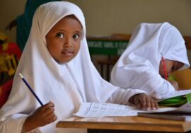
The current educational system consists of a primary education level with eight grades followed by secondary level education with four grades and university of 4 years. Overall, the number of students enrolled in primary schools, secondary schools and universities in Somaliland continues to grow rapidly. Primary schools have increased students enrolment from 35,997 in 1998 to 206,544 in 2014. The gender enrolment estimates in 2012/13 indicate that there are 3 girls for nearly 4 boys. Most of the schools were constructed with the help of aid assistance from the international community. The total number of students enrolled in secondary schools grew during 2007/08 from 19,146 to 20,489, which translates to an annual growth rate of 7%, but gender disparity in enrolment stands at 1 girl for 2.4 boys in the 2009/2010 school year. 63% of the secondary schools in Somaliland are public while 37% are private (Somaliland figures, 2014). There are also about seventeen universities with 2000 students graduating every year.
Health: The population of Somaliland which stands at 3.5 million is served by 25 hospitals, 91 health centres and 164 health posts. The health sector receives large amounts of assistance from international organizations (Somaliland figures, 2014).
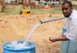
Water: There are no perennial rivers in Somaliland. People from urban town get water from the underground water sources particularly boreholes. The water supply for rural communities mostly comes from shallow wells, surface run off collected into the underground cemented cistern which is locally known as ‘’Berkad’’ and other water sources including earth dams and springs. Somaliland has established the ministry of water resources which has developed water regulatory frameworks including policies, water regulations, strategies and acts. This ministry is responsible for water related issues in Somaliland.
Economy: The backbone and mainstay of Somaliland’s economy is livestock, that contributes 60-65% of the GDP and 80-85% of foreign trade (exports) earning. About 65% of the population depends either directly or indirectly on livestock and livestock products for their livelihood. Crop husbandry provides subsistence for about 20% of the country’s population. Foreign aid and remittances from the Somaliland Diaspora also play a major role in the economy of the country. The contribution of livestock to the national economy is estimated at close to 28%. Thus, a large share of Somaliland’s people relies mainly on livestock products and by-products for their livelihood (Ministry of Planning and Development, 2010).
7.4. Natural Resources Context
Soils: Soil types closely follow the geomorphology of Somaliland. Soils are characterized by poor structure, high permeability, low moisture retention capability and inadequate internal drainage. Soil erosion is a major problem. This is a result of torrential rainfall on sloping terrain, heavy wind storms, overgrazing of livestock and vegetation clearing for farming purposes, fencing wood and charcoal production. Soil erosion has led to reduced water infiltration and a corresponding increase in runoff. Both gulley erosion and stream bank erosion is prevalent. Gully erosion is a threat to both farming and livestock production. It has already made large areas of land unproductive and is spreading at an alarming rate.
Vegetation: The vegetation of Somaliland consists mostly of grass, shrubs, and woodland. Grass and shrubs are mainly in the coastal plains. Shrubs and grass with scattered trees are dominant in the sub-coastal areas (north of the Golis Mountains). Evergreen trees and scattered shrubs, which are sometimes in clusters, can be found on the Golis Mountain. Open trees (woodland) are mainly in the plateau southeast and southwest of Hargeisa. The most common trees are Acacia and Commiphora species.
Land tenure and use: The land is a public property commonly owned by the nation, and the state is responsible for it (Somaliland National Constitution, Art. 12). In the past the rangelands were held either under a system based on customary water rights in the traditional clan-based land ownership system in which land was considered to ‘belong’ to families although there was no formal title deed. Land is mainly used for livestock production or mix crop and livestock production.
The use of different zones at different seasons is greatly influenced by fodder, pasture and water availability and by the seasonal activity of biting insects and ticks. The coastal grasslands are used for extensive livestock grazing especially in the dry season as water is more available in these areas than in the wood land. The bushy grassland areas provide a good source of wet season grazing and are favoured for camel and goats because of their browsing habits.
Farming practises: Somaliland agriculture sector contributes to 25% of the country’s livelihoods and is dominated by subsistence farmers, who practice rain-fed farming. Dry land farming accounts for nearly 90% of all agricultural activities with irrigated agriculture accounting for 10% of agriculture activities (Master plan for Somaliland agriculture sector, 2007 and Somaliland in figures, 2011). The main crops grown in Somaliland are maize, sorghum, millet and cowpea. Typically local varieties, including Elmi Jama, a late maturing sorghum variety is grown. Intercropping of different plants in the same field is common. Water melons and vegetables are also cultivated in some developed watersheds using rainfall runoff harvested in reservoirs along seasonal river banks. The geophysical characteristics of the shallow and stony soils in the mountains and piedmont areas and lack of adequate soil moisture in the coastal zone means that there is limited agricultural activities in these zones. Other limitations for crop production include soil erosion and low soil fertility due to the increasing trends of land degradation that further limits the suitability of agriculture in the marginal lands.
Land degradation: The SWALIM’s study has shown that land degradation is moderate to strong in Somaliland. About 37% of Somaliland is degraded and the most common degradation types are loss of topsoil due to wind and water erosion, loss of soil nutrient in agriculture productive areas (mainly western part of Somaliland), loss of vegetation cover (in eastern part, parts of north-western and south-eastern). Soil loss by water erosion and loss of vegetation were the most widespread types of land degradation in Somaliland. Although the degradation is moderate to strong, its trend is increasing. Therefore sustained and strategic measures are needed to control the degradation (FA0-SWALIM Technical Report L-10).
On the other hand, large concentrations of livestock together with the felling of trees for charcoal and firewood have had a profound impact on species composition, ground cover and the structure of vegetation. Grazing pressure and soil erosion are now a serious problem and, together with periodic droughts, have had a devastating effect on the vegetation and soils (Sommerlatte and Umar, 2000).
Land Policy and Legislations: There had been attempts in the past to develop national land policy but it has not been developed. The Somaliland Government has established a Land Policy Review Committee (LPRC) with task to develop a comprehensive land policy. The process of developing a land policy is one and this report will contribute towards this process through providing evidence based information on land and natural resources situation in Somaliland.
Rain fed agriculture is the main agricultural production system, and is practiced in the Baki and Borama districts (Awdal region) and in Gabiley region and the Faraweyne and Hargeisa districts (Maaroodi-Jeex region). A smaller portion of the country has irrigated agriculture along the river valleys. The Somaliland authorities recognize the need for land use planning and zoning and consultations have been going on between relevant Government ministries and traditional leaders aimed at resolving the emerging conflicts caused by spontaneous settlement and enclosure of rangelands. The major land policy areas of concern are:
- Demarcation of pastoral rangelands and farmlands,
- Abolition of all enclosures illegally held by communities and return to common property status,
- Restoration of all previous governmental range reserves to the relevant agencies
- Promotion of land management among concerned governments institutions, traditional leaders and communities.
- Expansion of urban areas into rural territories (specifically grazing land)
Land is governed under plural legal system, namely Sharia, Statutory and Customary laws. Existing statutory laws related to land governance are as in the table below.
Land policy, laws and acts Institution
Agricultural Land Registration Act, 2008, draft Ministry of Agriculture
Somaliland Agricultural Policy, 2008, draft
Somaliland land tenure policy, 2008, draft
Prevention of Deforestation and Desertification Law (Environment Conservation Act and Proclamation)- Law No. 04/1998, approved Ministry of Environment and Rural Development
Somaliland Rangeland Policy, 1999, Draft
Law on Forests Conservation and Fauna Law No. 69/2014
Presidential Decree No. JSL/M/WM/222-2689/092014
Urban Land Management Law No.17/2001Law on Fauna
(Hunting) and Forest Conservation Law No. 15/1969 Ministry of Public Works and Housing
Prevention of Degradation and Deforestation law No.04/1998
Ministerial Regulation on Land Dispute Law. No. 01/2014
Coordinating the development of the Somaliland Land
Policy Development (on-going) Ministry of National Planning & Development
Presidential Decree No. JSL/M/MG/081/1-3495/082015
National Water Law No. 49/2011 Ministry of Water Resources
Law of livestock No. 34/2006 Ministry of Livestock
Somaliland Fishery law(N0:24/1995) Ministry of Fisheries and
Marine Resources
Mining code Draft(N0:—/2000) Ministry of Mines
7.5. Public Service Delivery and Information Management Context
With an economy dependant on natural resources, the absence of reliable information to facilitate allocation and re-distribution of resources and planning presents major challenges. Yet, good- quality water and land information is widely recognised as crucial to relief, rehabilitation and development initiatives for Somaliland. Somali Water and Land Information Management project (SWALIM), has been in operation since 2003 to provide critical water and land resources related information. SWALIM does this by retrieving lost data and building upon them to create and make available a wealth of information for sustainable water and land resource management. However, if the capacity required to manage such a system is not developed, this service will continue to be sourced externally. To meet this need, SWALIM aims at building the capacity of the Somali institutions and individuals to enable them continue with the generation, communication and use of water and land information by Somalia’s public sector.
7.5. The Livelihood context: a zonal perspective
In Somaliland the major livelihoods from the land resource comes from pastoral, agro-pastoral and Silva-pastoral activities. The rural economy is based predominantly on these activities in the form of livestock, agriculture, forestry and their associated trade. Although Somaliland has growing urban centres that consumes large quantitates of food items, nevertheless the practice of value chain is almost non-existent and the local products from the livestock and agriculture is marketed without adding any value. On the other hand imported dairy products, poultry and other agriculture products is a common scene in these urban centres. From the land resource perspective, Somaliland is divided in seven livelihoods zones (with considerable overlaps) as follows:
- Guban Pastoral and Mountain Livelihood Zone
The Guban pastoral livelihood zone covers the northwest, along the coast, and is known to have strong connections with the Middle East. Many of the Somalis in this area are of the diaspora origin, thus substantial remittances are received from abroad in this zone. This zone also supports good livestock conditions due to reasonable water sources available in the mountains and camel, cattle and goats/sheep is the common livestock, owned by pastoralists. In general animal and human population have increased over the last few years with high numbers of returnees from southern and central Somalia. Due to the stable security situation since 1996 and favourable natural environment for livestock this is relatively wealthy area with diversified livestock holdings and a more guaranteed mountainous water supply as cattle are predominantly found in the mountainous areas. 70% of the total livestock population are sheep, 25% goats, 4% camel and 1% cattle. 80% of herd composition in mountainous zones is goats, whilst in the Hawd plains 75% are sheep.
- West Golis Pastoral Livelihood Zones
The West Golis livelihoods zone comprise of highlands that crosses Togdheer, Waqooyi-Galbeed and Awdal regions of Somaliland. With highest peaks located around Sheikh the altitude of the zone reaches to over 2000 meter a.s.l and intercepted with valleys. Together with palatable grass species, the vegetation cover is dominated by shrubs and trees, mainly Acacia species. This vegetation cover adequately supports the livestock and thus the livelihoods predominantly comprise livestock rearing – sheep, camel and mainly goats. Together with sporadic springs, the main water source is shallow wells in the valleys and during dry seasons water scarcity is experienced in the zone. Based on these resources irrigated agriculture is practiced sporadically and mainly on subsistence basis.
- North West Agro-Pastoral (NWAP)
North West Agro-Pastoral (NWAP) livelihood zone extends west of Togdheer agro-pastoral livelihood and is bordered by West Golis Pastoral to the North and Hawd Pastoral to the south and Zone 5 of Ethiopia to the west. With topography ranges from 1000 to 1700 altitude, this zone is a prime crop (sorghum and maize) and cattle production area. Parts of the area have been under sorghum and maize cultivation since the 1930s and in the 1990s it was the only significant area of sedentary cultivation in Somaliland. Most of the zone is composed of scattered acacia trees, but in the arid areas of the northeast, grasslands give way to a combination of low brushes and grass clumps. The main water sources are Ballis (rainwater catchment) in the slopes of the Golis Mountains and shallow wells in the northern part. Crops growing, livestock production and trade are the major livelihood related activities.
- Togdheer agro-pastoral livelihood zone
The zone is closely linked with the urban and Hawd pastoral communities through livestock/products trade, sale of charcoal, access to labour and kinship support. The population of Togdheer Region is estimated at 402,295 persons (30% urban, 65% nomadic pastoralists, & 5% agro-pastoralist). The area has traditionally been used as a grazing area with small pockets of rain-fed cultivated land. The Main crops of the zone are sorghum, maize, cowpea, water melon and vegetables. Grass production and sale is a vital income source for the middle & better-off and provides labour opportunities (grass cutting) for the poor. Wealth determinants are mixed livestock and cultivated land. Both assets have reduced in recent years due to limited farm inputs and recurrent droughts. Income sources include livestock and its product sales, petty trade, fodder sales and labour. Burco market is a dynamic and rapidly expanding centre, the zone also benefits from its proximity to Berbera port and Burco/Yaroowe markets with access to livestock trade and opportunities for fodder sales and employment. Nevertheless, recurrent shocks (drought & disease) have affected livestock herd sizes, forcing some pastoralists to shift in to farming around streams or moving to urban centres looking for jobs.
- Hawd pastoral:
The Hawd Pastoral livelihood zone extends from the North West in West Galbeed to the highlands of Togdheer and Galbeed in the North, traverses the foothills of the Golis range in the East, eventually merging with the wider Hawd plateau in the Somali region of Ethiopia. The region benefits from bimodal rainfall: Gu (April-June) and Deyr season (October- November). Some Western parts of Togdheer and the South of Waqooyi Galbeed region experience short cycle karan rains (mid-August-September). The dominant species reared include sheep/Goat and camel.
- Northern inland pastoral – Goat and sheep
This sheep and goat (shoat) pastoral livelihood zone is among the largest pastoral livelihood zones in Somaliland. Soil and vegetation varies, but have common resemblances. The rangeland conditions are under continuous degradation due to persistent droughts, overgrazing and proliferation of berkads/boreholes. The Annual Rainfall (100-200 mm) is erratic with very high evapotranspiration rates. Berkads and Boreholes are the main water sources in Sool area. Main socio-economic activity is pastoralism, as livestock is the key livelihood asset (Shoat/camel etc.). Sale of livestock and livestock products is the main source of income. Purchase of imported food commodities complimented by some portion from livestock products and food aid are commonly accessible. In general there is heavy reliance on livestock export and food supply through Bossaso port.
- East Golis Livelihoods Zone
East Golis pastoral livelihood zone is characterised by the frankincense, goat, sheep & camel and artisanal fishing related livelihoods activities. The zone covers an area of approximately 41,380 square kilometres, with rugged terrain and mountain ranges that are incised by dry seasonal rivers and ravines. The slope in this livelihood zone is steep in the area around Ceerigaabo and the Golis Mountains; and slightly flatter towards the Gulf of Aden. The zone receives two seasonal rainfalls separated by two dry seasons. Livestock reproduction and productivity peaked at water and pasture availability in the Gu and Deyr seasons. These periods coincide with increased milk availability, which contributes to improved household dietary needs and income from livestock products. Livestock sales usually peak in May and October, due to improved livestock body conditions, good water and pasture availability and high demand due to the Eid and Hajj festivities. Low milk availability occurs in Jiilaal and mid-Hagaa seasons, due to low water and pastures production and out migration of livestock away from pastoral catchments.
In this zone tapping and selling frankincense is a key livelihood activity, its production is negatively affected by droughts, storms and winds which sometimes lead to trees falling, termites, plant borers and overexploitation of trees. Seeking of social support and credit is a key coping strategy perfected by poor households in the livelihood zone. For instance, most poor and lower middle households seek credit during the onset of the Frankincense production period and repay the debts during the peak harvest periods around August, the period when the price of frankincense is high.
- Integration, Conclusion and Recommendations
Coastal plain and Piedmont: (comprised of the coastal belt, including the towns of Laasqoray and Berbera, and is wider in the west covering most of Zeylac and Lughaye).
Climate: with a total rainfall (uni-modal) of less than 100 mm per annum and a temperature range of 28-35 ⁰C, (e.g. where potential evapotranspiration exceeds rainfall by thirty times), the landform is characterised by extreme aridity.
Soils: The soils of the region are comprised predominantly Arenosols (48%) and Regosols (24%). The highly arid climate affects the soil formation process and the soils are poor in texture, structure and fertility. The aridity, together with the absence of adequate land cover, facilitates erosion and sheet and gully erosion is a common phenomenon in the landform. This process is leading to perpetual soil impoverishment in most of the landform. Nevertheless the soil diversity and status improves in the north-western part of the landscape.
Land cover: the predominant land cover (over 95%) is comprised of herbaceous vegetation and bare area, with 4% woody vegetation scattered between Lughaye and Berbera. Only some 3 Km2 (0.02%) near Berbera supports irrigated agriculture.
Land use: the land use of this landform is mainly nomadism and transhumance pastoralism.
Mountain and Highlands: This comprises the Al and Golis Mountains and lies to the south of Laasqoray, north of Ceerigaabo and around Sheikh, South of Hargeisa and Borama.
Climate: The landform receives 500 – 600 mm of rain around Borama and 300 – 500 mm around Sheikh and Ceerigaabo: the rainfall is distributed in two seasons. The temperature ranges from 20 to 24 degrees Centigrade and the ratio between rainfall and potential evapotranspiration is almost equal, the most balanced in all of Somaliland.
Soils: The major soil class is Leptosols (59%) which are predominantly rocky and shallow, followed by Cambisols (22%) which are deeper and loamy. The soils generally lack fertility despite being well stocked in potassium and micro-nutrients. Adequate rainfall and lower aridity means the soils in the less sloping lower reaches are better developed.
Landcover: the landcover comprise herbaceous vegetation over 32,985 Km2 (63 %) and woody vegetation over 7,372 Km2 (14%), with more than 21% bare area. The vegetation is concentrated in the Golis Mountains but also in the areas surrounding Borama and Hargeisa.
Land use: a considerable part of this landform is still under nomadic pastoralism, with 16% in transhumance pastoralism and 2% under agriculture. Given the large extent of the landform, this comprises around 1,000 Km2.
Plateaus: (comprised of Burco, Oodweyne, Caynabo, Ceel-Afweyn, Dhahar, Badhan, Wajaale, Gebiley, Borama and Hargeisa)
Climate: The landform receives 500 – 600 mm of rainfall south of Borama and Gebiley, and 300 – 500 mm around Burco and Oodweyne; the rainfall is distributed in two seasons. The temperature ranges from 20 to24 degrees Centigrade and the ratio between rainfall and potential evapotranspiration is one to one and a half, therefore a manageable climatic situation.
Soils: The soils in general are deep, low in nitrogen and phosphorus, high in potassium and other micro nutrients. Salinity is found in cambisols, but absent in other soil types. Generally the soils are productive and the fertility can be replenished by adding nutrients.
Landcover: This landform represents the largest portion of Somaliland and 39,156 Km2 (52.3 %) is covered by sparse or herbaceous natural woody vegetation, 19,303 Km2 (21.8%) is covered by closed to open natural woody vegetation, with 1,936 Km2 (2.6%) area under rainfed agriculture and 174 Km2 (0.2 %) under irrigated agriculture. Around 23% of the area lying in the east of Ceel Afweyn is bare.
Land use: around 70 million hectares (over 90% of the area) of this landform together is under nomadic pastoralism (60%) and transhumance pastoralism (30%), with 256,000 hectares under agro-pastoralism (3.4% of the area of this landform). This implies that most of this landform is dedicated to pastoralism.
Valley (comprised of Laascaanood, Caynabo, Taleex and Xudun)
Climate: With total rainfall of less than 200 mm per annum (distributed in two season) and a temperature range of 28-32 ⁰C, the potential evapotranspiration exceeds the rainfall by seven times, meaning the landform is characterised by high aridity.
Soils: The soils of the valleys comprise clayey Calcisols 35%, silty or sandy Solonchak 24%, sandy loam Regosols 20% and stony or rocky Leptosols 19%. Where the calcisols and solonchaks are deep, however, the other two types are shallow. Except for the solonchaks, salinity is absent in the soil types of this landform. The soils are low in nitrogen, adequate in phosphorous and high to average in potassium.
Landcover: In this landform 57.3 % (16,738 ha) is covered by sparse or herbaceous natural woody vegetation, 16.8% (4925 Km2) is covered by closed to open natural woody vegetation, and only less than 0.26% (78 Km2) southeast of Burco has irrigated agriculture. The rainfed agriculture is nominal in this landform. Over 25% of the area is bare, stretching east to west of this landform, south of Xudun and Taleex.
Land use: around 2.8 million hectares (over 94% of the area) of this landform together is used for nomadic pastoralism (77%) and transhumance pastoralism (18%), with only 2,165 hectares under agro-pastoralism (0.1% of the area of Somaliland). This landform is also characterised by timber collection and charcoal production activities.
Challenges and Gaps in the sustainable management of the land resources of Somaliland:
Based on the overall analysis, the land resource of Somaliland poses the following challenges and gaps that need to be addressed to ensure the sustained supply of its products and services:
Bio-physical challenges:
Aridity: Due to high temperatures and low availability of rainfall, the evapotranspiration in most cases far exceeds the rainfall, except in areas within the mountain and highlands and a small proportion of the plateau. Areas along the coast and in valleys face extreme aridity.
Ground water challenges: the ground water availability presents challenges of quantity, quality, distribution and high development cost. Besides limitations in quantity, the
distribution is skewed and the underground reservoirs pose disjointed distribution. The quality is marred by salinity in many cases.
Surface water challenges: Somaliland is receiving substantial amount of rains in the wet seasons, however the rains rather than replenish the ground water and/or become a source of irrigation, turn into perilous source of run-off and thus leads to accelerated erosion both sheet and gullies. Reliable information is not available on the extent, timing and location of the surface water availability, SWALIM conducted a study at Tog Waheen and its recommendations are reflected in this report.
Climate shocks: Changing climatic patterns shift from protracted droughts (especially in the eastern part of Somaliland) to floods in the seasonal rivers. The situation is exacerbated by the poor land cover on one hand and the inadequate preparedness for these hazards. The hazards of drought and flood trigger livelihood crises and that in turn lead to further degradation of the land, as the need for survival compels local people to exhaust any left-over vegetation through over grazing and deforestation.
The fertility of the soils: Evidence of declining fertility cannot be established definitively. Although the soils have adequate Potassium and micro-nutrients, they are generally poor in phosphorus and, in particular, nitrogen. Surface salinity in uncommon, but the soils are alkaline and crops requiring neutral soils have less prospect of.
The soil texture also presents major challenges, as loamy and deep soils are found only in some parts of the highlands and plateau landforms. Beyond these areas, most of the soils are either excessively stony or sandy, with limited prospects for crops.
Accelerated erosion: Erosion by wind and water is common and leads to further degradation of the soil and vegetation. In dryer areas along the coast, and also in parts of eastern Somaliland, sand dune formation is a common phenomenon. The formation of ever- expanding gullies is seen in sloping areas.
Low biomass production: due to the bio-physical constraints in general, and the aridity and inadequate ground water specifically, Somaliland is faced with low biomass production that
perpetuates other issues related to soil fertility and the production of ecosystem goods and services.
Invasive species: Several invasive species (such as Prosopis, Opuntia, Parthenium species, etc.) threaten the land resources of Somaliland. Among these species Prosopis poses the major threat as this is encroaching mainly productive areas under agriculture or forestry. Prosopis is widely spread across Somaliland with a particularly high concentration in the Woqooyi Galbeed region. The pattern of invasion confirms that it invades first lowlands next to rivers and Wadis as well as peri-urban areas both inland and along the coast.
Management Challenges:
Absence of holistic planning and management of land resources: land resources in general and the various land uses in particular toned to be managed in a cohesive manner. This is imperative in a complex conglomeration of land uses that depend on each other. These ecosystems also require a holistic approach that brings together the social, ecological and economic realities. However, in Somaliland integrated planning and management is absent.
Absence of value-added sustainable use of land resources: the resources are not processed and used in a value-added manner. As a result, while the land resources are over-exploited, the socio-economic returns are much less relative to the corresponding resource use.
Lack of the use of modern technologies and input intensive management: input intensive management and the use of modern techniques and technologies is the exception rather than the prevailing practice.
Ecosystem fragmentation and degradation: Shaped particularly by deforestation, erosion, gully formation, encroachment for agriculture and infrastructure, the degradation of the ecosystem adversely affects the productive potential of land in Somaliland in general and the drier parts of the Sool and Sanag areas in particular. The deforestation for charcoal, mostly for commercial purposes, is another leading factor in deforestation and ecosystem degradation.
Free and extensive grazing of large concentrations of livestock, together with the felling of trees for charcoal and firewood, have had a profound impact on species composition, ground cover and the structure of vegetation. Grazing pressure and soil erosion are now a serious
problem and, together with periodic droughts, have had a devastating effect on the vegetation and soils.
The free/over grazing has led to habitat degradation in multiple ways, such as the stunted growth of vegetation due to browsing pressure. Over-grazing has also marred the natural regeneration of the woody vegetation. The “hoeing” phenomenon, together with the removal of the vegetation cover, has facilitated gully and sheet erosion. Thus the process of land degradation is perpetuated by the mutually reinforcing factors of soil erosion and the suppression of the regenerative capacity of the natural vegetation – the protective cover of the soil and habitat in general.
Selective deforestation: Acacia species are the most favoured trees for making charcoal, as well as for timber and other uses. These species, belonging to the Leguminosae family, uses atmospheric nitrogen, thus allowing it to survive in nitrogen poor soils while enriching the soils naturally. The removal of these trees deprives the otherwise nitrogen poor soils of Somaliland of their only source of natural enrichment.
Unsuitable or unproductive land for farming: cost-ineffective agricultural practices are widely practiced, specifically in areas which are otherwise not fit for agriculture. Farmers soon abandon these lands for another patch of (unfit) land to see the same fate repeated again and again. . This renders a substantial amount of land completely unproductive.
Infrastructure deficit: essential infrastructure, in the shape of farm-market roads, marketing infrastructure, storage facilities, etc. are largely not available.
Increase of unpalatable plant species in plains: overgrazing is leading to the depletion of palatable species and the infestation of less-palatable species. This increases food insecurity for livestock in a place where the economy depends greatly on livestock.